Evergreen NASP Amendment & Rezoning
What is happening?
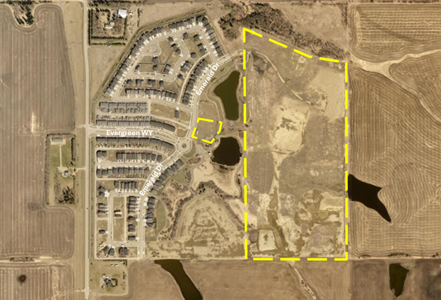
An application was received to redesign the eastern half of the Evergreen Neighbourhood Area Structure Plan on land currently undeveloped.
Additionally, a rezoning application was received for the northeastern portion of the redesign and a central remnant parcel, to help facilitate the redesign as proposed.
With the redesign and rezoning, it is anticipated that 199 more dwelling units and 420 more residents will be provided in the Evergreen Neighbourhood.
What is a Neighbourhood Area Structure Plan?
A Neighbourhood Area Structure Plan (NASP) is a required land use concept plan that must be prepared by a developer for any large undeveloped parcel of land, generally one quarter section (160 acres) in size or larger.
The NASP requires City Council approval. To facilitate future zoning and subdivision decisions, these plans must provide a detailed level of planning information including, but not limited to:
- land uses
- all road and lane locations
- types of residential/commercial/industrial development
- number of dwelling units
- community trail and park development
- utility infrastructure and storm water management facilities
- density
Once a NASP is approved by City Council, changes can occur. A change can be proposed by a developer or landowner in the neighbourhood. Changes to a NASP also require City Council approval.
The Evergreen NASP was approved in 2014, with changes approved in 2019 and 2021.
In 2014, City Council approved the Evergreen NASP.
Evergreen Neighbourhood Area Structure Plan Amendment
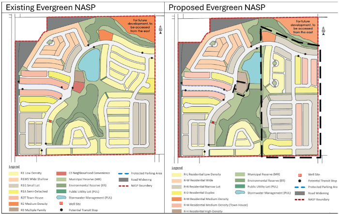
The applicant is seeking to redesign the eastern half of the Evergreen NASP, changing the residential layout and road network to allow for more narrow lot housing, duplexes, and townhouses. The potential commercial site on the western edge of the central park is proposed to become high-density residential. Various corresponding updates to the plan corresponding with these changes are made throughout the document.
Further changes are proposed to bring the plan in alignment with policies and bylaws that have updated since the NASP was last amended.
- Proposed Evergreen NASP 2025 (pdf)
- Current Evergreen NASP 2021 (pdf)
- Comparison - Current and Proposed Evergreen NASP Changes (pdf)
Future Development of the Remnant Parcel West of the Pond
The NASP currently indicates that the remnant parcel (indicated with a red star above) will be developed for neighbourhood commercial, or alternatively, multi-family development if the site is unable to be sold for commercial purposes. The developer is proposing that the site be rezoned to allow for multi-family development. This is consistent with what was originally planned for the site.
A design for the site and the parcel to the north is being worked on. The following is a draft plan and not final: Potential Residential High-Density Zone (R-H) Build Out (pdf)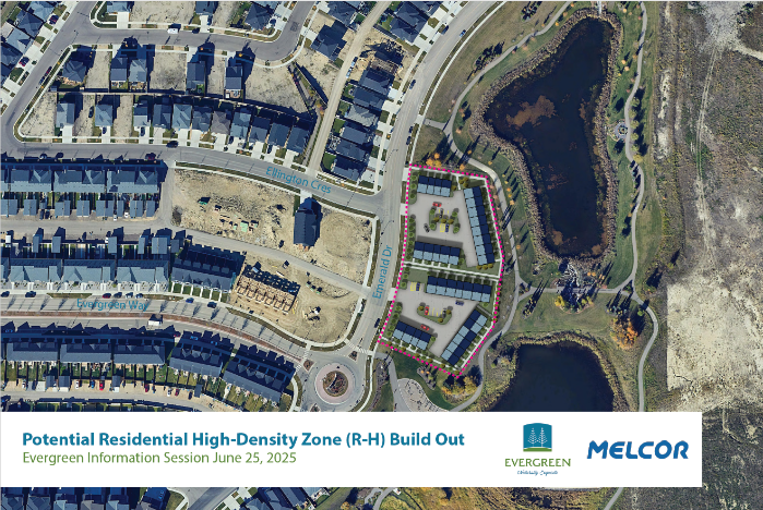
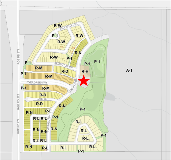
Rezoning Application
What are Zones and what do these Zones mean?
Zones are the overarching rules that determine what can and cannot be built or operated on a given site.
The following table provides an explanation of the zones proposed and general development expectation of each zone.
| Zone Code and Name | General Development Expectation |
| R-L (Residential Low-Density) | Typically single detached houses, with some limited additional housing suites or duplexes allowed. |
| R-N (Residential Narrow Lot) | Typically single detached houses, with some limited additional housing suites allowed. Lot widths are generally narrower and may include zero-lot line developments. |
| R-D (Residential Duplex) | Typically duplex developments, though some single detached houses with limited additional housing suites may be allowed. |
| R-M (Residential Medium- Density) | Typically townhouse or apartment-style developments, limited to 3 storeys in height. Duplexes can also be allowed. |
| R-H (Residential High- Density) | Typically apartment-style developments of up to 6 storeys in height, and may have limited commercial on the main floor. Can also include more compact forms of 3-storey townhouse developments. |
More detailed information on the exact permissions and allowances of a Zone can be found in the Zoning Bylaw.
Proposed Zoning
In addition to the Evergreen NASP changes, the applicant has applied to rezone the northeastern portion of the redesign, as well as a remnant parcel along the central park area. Proposed Rezoning Map (pdf)
The lands are currently zoned A-1 (Future Urban Development) Zone. For more information on zones current and proposed, please view the following links:
- A-1 Zoning Regulations (pdf)
- R-N Zoning Regulations (pdf)
- R-L Zoning Regulations (pdf)
- R-D Zoning Regulations (pdf)
- R-M Zoning Regulations (pdf)
- R-H Zoning Regulations (pdf)
- P-1 Zoning Regulations (pdf)
What are the next steps?
It is expected that the application will be brought to City Council for their consideration in the coming months. There are three steps in the Council process.
- Step 1: Council reviews a report and administration’s recommendation when considering First Reading. If First Reading is granted, the application moves onto step 2.
- Step 2: A Public Hearing is held where the public is given an opportunity to speak directly to Council about a proposed change. Public Hearings are advertised in the Red Deer Advocate and all landowners within the consultation area will receive written notification of the Public Hearing. Once the Public Hearing is closed, the application moves onto step 3.
- Step 3: Council considers Second and Third (final) Reading of the proposed change.
Do you have comments?
All members of the public will have the opportunity to address Council about the proposed amendments at the Public Hearing. When a date is scheduled for the hearing, it will be advertised in the Red Deer Advocate, on the City’s Public Hearing webpage and letters will be mailed to landowners within the consultation area.
Questions?
Christi Fidek, Senior Planner
christi.fidek@reddeer.ca